Roamin’ Through History at Two Miles Per Hour
A British national trail provides a walker's-eye view of Roman ruins
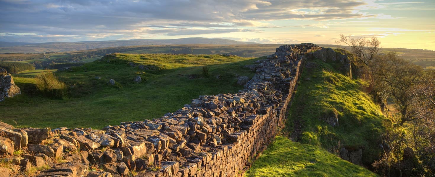

The harsh prevailing wind from the Irish Sea buffeted our backs as we climbed 1,135 feet to the top of Windshields Crag in Northumberland, England. My husband and I were nearly at the midpoint of our eight-day, 84-mile trek, walking eastward along Hadrian’s Wall, a path the Romans had forged early in the second century A.D. At the summit, we looked south over a bucolic English countryside: a patchwork of gently rolling farmland dappled green and gold, with the occasional speckle of a sheep grazing in the fields. To the north toward Scotland, a rugged landscape supporting only scrub and a few gnarly trees unfolded before us. Yet perched precariously atop this lonely ridge, we had no fear of tumbling into the abyss. The stone wall beside us, a massive tawny-gray caterpillar crawling east and west across the undulating terrain, assured us we’d be safe. In fact, it’s been protecting people for nearly two millennia.
RUINS IN NORTHERN ENGLAND
This is Hadrian’s Wall, completed in completed in A.D. 122 by the eponymous Roman Emperor to mark the northern boundary of his empire. It spans Great Britain at its narrowest point near (but not at) the current Scottish border, reaching from the Solway Firth at the Irish Sea in the west to the North Sea at Wallsend (near Newcastle) in the east. As they did with the Colosseum, the Romans built this structure to last. The original stone wall was more than 15 feet high and 73 miles long and was supplemented with a sophisticated system of earthen mounds and ditches near the coasts. Much of this combined fortification remains, and in 1987, Hadrian’s Wall was designated
a UNESCO World Heritage Site.
Hadrian's Wall Milecastle 37
There’s far more Roman history in this part of northern England than simply a wall, though. As the northern boundary of the Roman Empire, life was thriving in northern “Britannia” nearly 2,000 years ago. Forts built along the wall led to bustling towns nearby to support the garrisons. Even today, farmers plowing their fields sometimes discover the remains of a Roman archway. The Roman influence endures along the wall in museums and an active archaeological dig as well as with a veritable playground of Roman ruins to explore.
FOLLOWING THE ROMANS
With this much on offer, where should you begin? Fortunately, the dual British loves of history and ambling through the countryside combine to create the perfect answer: the Hadrian’s Wall Path. Opened in 2003, this 84-mile national trail traverses the country—down rural lanes, through sheep pastures, into quaint English villages and along barren escarpments—with an abundance of Roman sites along the way.
Hiking the Hadrian’s Wall Path would give us the opportunity to see these historical sites up close and at our own pace. I was celebrating my 60th birthday with this trip, and walking the path from end to end seemed a fitting way to mark this milestone.
The path provides a nice trek for non-hardcore hikers. But what really sealed the deal for us was that we could complete the walk as a series of point-to-point day hikes, sleeping in bed-and-breakfasts each night while our luggage was portered each day, leaving us to carry just light daypacks with water, snacks and raingear.
Our first morning in mid-May dawned clear and sunny, promising ideal weather. This, and our last day, would be our longest walks—15 miles each—due to the relatively flat terrain near the coasts.
Just one mile into our journey, at the hamlet of Port Carlisle, we encountered a signpost overseen by the avuncular Roger Brough. The retired septuagenarian greets trail walkers heading in both directions, and for the fee of one pound (that’s $1.29, which he assured us went to charity), he puts the mileage of your hometown on the signpost for a photo op. After we posed for a few shots, he encouraged us with these parting words: “Take heart—you’re 1.2 percent through!”
FLAT LANDS, LAYERS OF HISTORY
The Hadrian’s Wall Path can be divided roughly into thirds. The outer sections, about 27 miles each, are near each coast and cover primarily flat terrain. Thus, they were often plundered through the centuries, translating into fewer and more subtle Roman ruins to see. In these areas, the stones of Hadrian’s Wall were “recycled” into farmhouses, churches and barns. Nevertheless, intrepid explorers can find evidence of past civilization: the sophisticated system of mounds and ditches constructed on either side of the wall is still evident in the sheep pastures and along country lanes, even though the wall itself is gone.
Recycled bits of wall show up in random spots. The ruins of 12th-century Lanercost Priory (which fell into disrepair in the 1500s with Henry VIII’s dissolution of monasteries) show Roman remnants: some of the remaining walls of the priory include large, precisely squared Roman stones at their base. It’s remarkable to contemplate that a church built 900 years ago used stones from a structure that had been erected nearly a millennium earlier.
THE HEART OF THE WALL
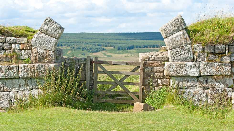
In the path’s central section, roughly 30 miles long, the terrain includes hills as well as steep crags that were formed by igneous rock piercing the Earth’s crust 295 million years ago. In this section, much of the Roman wall remains intact (albeit not at its original 15-foot height), and the Hadrian’s Wall Path follows directly alongside it. The Romans constructed the wall methodically. A milecastle punctuated the wall every Roman “mile” (approximately 5,000 feet), with two equally spaced turrets that served as observation points between each milecastle. Milecastles were gateways housing 8 to 32 soldiers, designed to control movement in and out of the empire, much like a modern-day border crossing. In addition to 80 milecastles, 16 forts, each built to house 1,000 men, were constructed either astride or just south of the wall.
Today, ruins of four of those forts remain, with adjacent museums and interpretive centers describing both the ruins and life in Roman times. The remains of each fort differ slightly. For example, Birdoswald, the westernmost fort, still has intact perimeter walls, providing a sort of stone floor plan to the fort, while Chesters, built at a low point along the river North Tyne, has well-preserved remains of a Roman bath. As wall-walkers, we appreciated the modern-day comforts that have been provided for tourists at these forts: each contained restroom facilities and cafes/picnic areas.
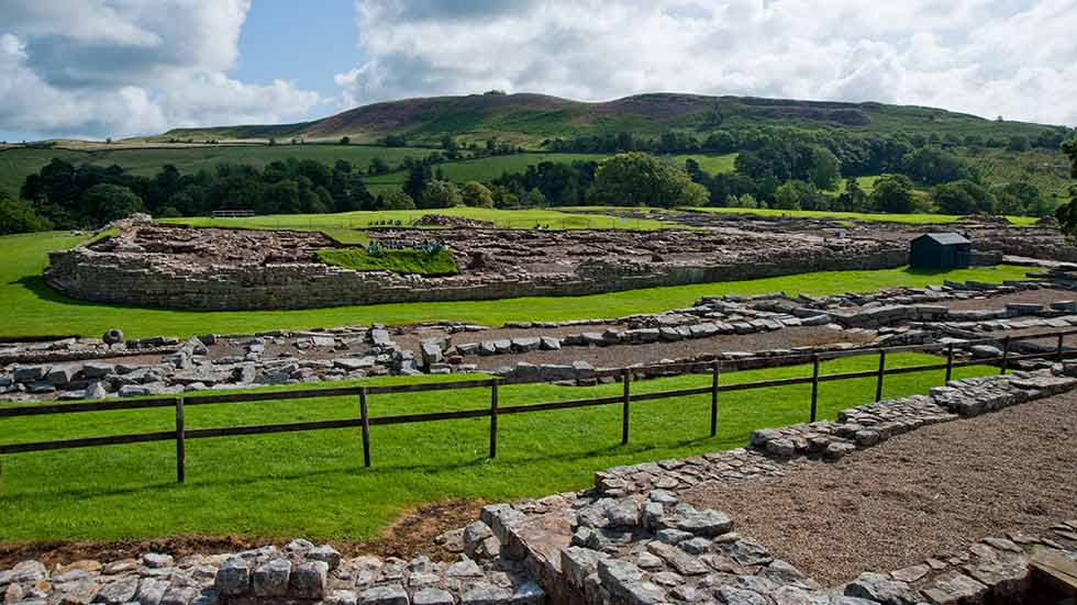
Roman Vindolanda Fort and Museum
Near Windshield Crag and the wall’s midpoint is Vindolanda, a former Roman settlement that is the site of an ongoing excavation. We took a day off from walking to explore the site, located one mile south of the wall. Visitors are welcome to watch the excavations at what’s widely considered the most significant archaeological site of the entire Roman Empire. Workers were digging at the ruins of a former residence during our visit. As an archaeologist was explaining the day’s activities to us, a volunteer approached her gingerly, holding a small item in his palm. She exclaimed, “Look, Lewis has found an intaglio!” The small carved gemstones were often used in Roman signet rings.
The Roman Vindolanda Fort & Museum contains a remarkable collection of leather shoes and sandals that have survived two millennia due to the unique low-oxygen soil conditions at the site, which prevent natural decay. The shoes were surprisingly elegant and delicate, but we were quite happy to be wearing our 21st-century hiking boots in this rugged terrain.
Back up on Windshields Crag, we pondered the life of a Roman centurion, who, some 1,900 years ago, traversed this same desolate ground without the benefit of modern hiking boots or rain gear. In contrast, the final 40-odd miles of our trek on the Hadrian’s Wall Path would be relatively easy, and I had a birthday challenge to complete. We tightened our laces, gripped our hiking poles and soldiered on.
Larissa Milne and her husband, Michael, have been global nomads since 2011.